Volcanic ash from Mount Ruang still disrupts flights in North Sulawesi
Volcanic ash from the eruption of Mount Ruang is still disrupting flight operations in the North Sulawesi region.
This article has been translated using AI. See Original .
About AI Translated Article
Please note that this article was automatically translated using Microsoft Azure AI, Open AI, and Google Translation AI. We cannot ensure that the entire content is translated accurately. If you spot any errors or inconsistencies, contact us at hotline@kompas.id, and we'll make every effort to address them. Thank you for your understanding.
By
PRADIPTA PANDU
·3 minutes read
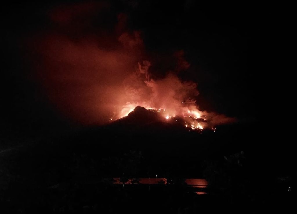
DOKUMENTASI BPBD SITARO
The eruption of Mount Ruang in the Kepulauan Siau Tagulandang Biaro (Sitaro) Regency in North Sulawesi occurred on Tuesday night (16/4/2024). Hundreds of residents were evacuated.
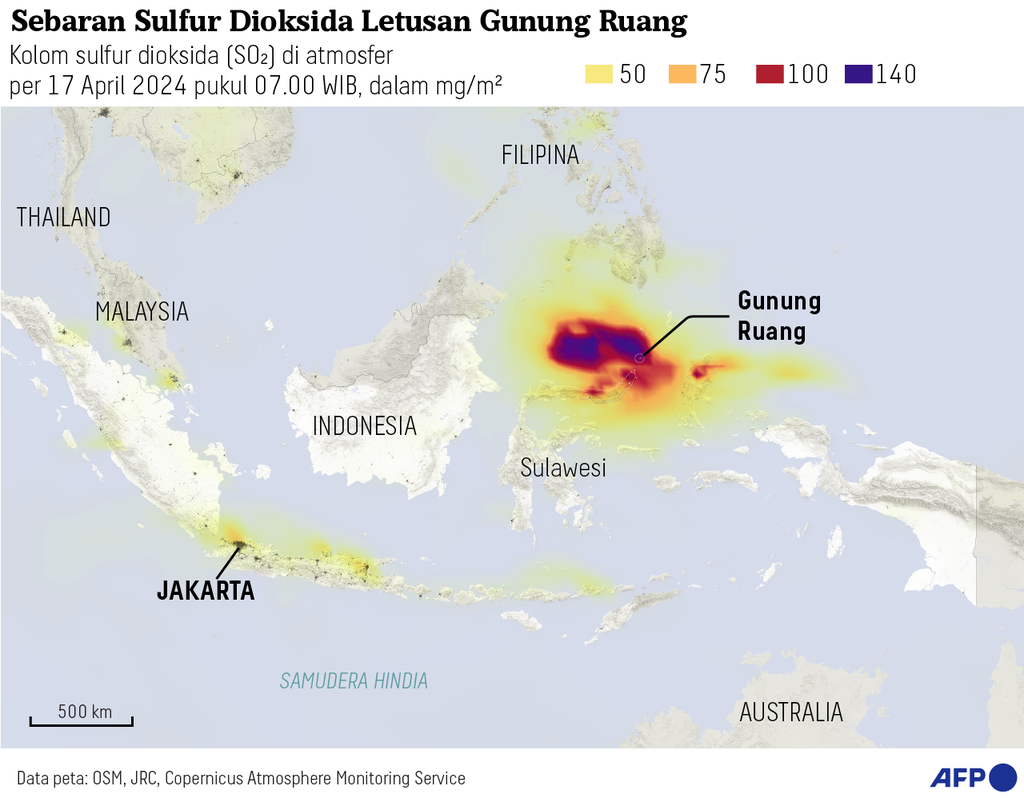
JAKARTA, KOMPAS — The eruption of Mount Ruang in the Siau Islands Regency Tagulandang Biaro or Sitaro, North Sulawesi, released volcanic ash which disrupted flights in Ignite. Operational activities at Sam Ratulangi International Airport in Manado City are still closed to all flight activities.
According to the report from the National Disaster Management Agency (BNPB), volcanic ash from the eruption of Mount Ruang is still disrupting the air space area until Friday (19/4/2024). This condition has an impact on flight safety and security.
The eruption of Mount Ruang that occurred since Tuesday (16/4/2024) had an impact on the operational closure of Sam Ratulangi International Airport in Manado City, North Sulawesi. The closure of the airport, which is approximately 95 kilometers away from Mount Ruang, was extended until Friday (19/4/2024) from 06.00-18.00 WITA.
The Head of the Disaster Information and Communication Data Center of BNPB, Abdul Muhari, conveyed that the distribution of volcanic ash from Mount Ruang was monitored up to North Minahasa Regency on Thursday (18/4/2024).
A number of areas affected by volcanic ash include West Likupang, Wori, East Likupang and South Likupang sub-districts.
"The North Minahasa Disaster Management Agency (BPBD) urges residents to use masks and remain calm, especially in responding to hoax information," said Abdul in his written statement on Friday (19/4/2024).
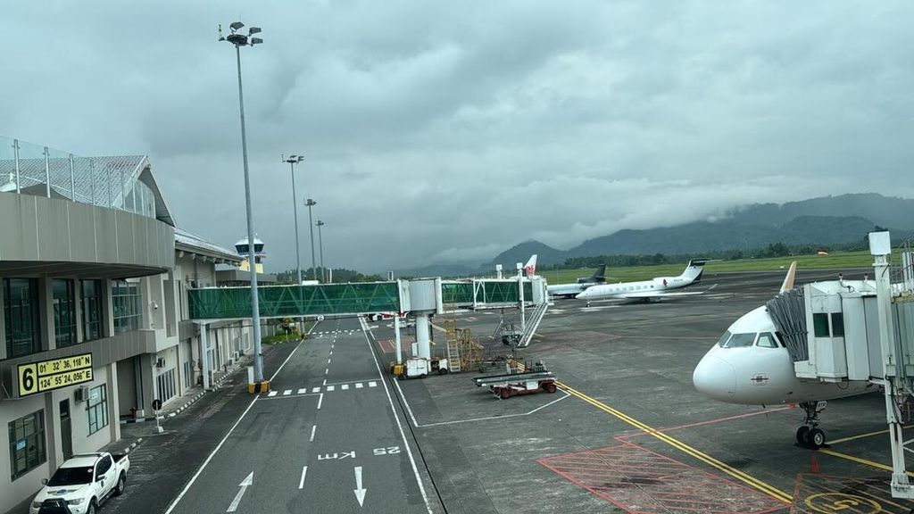
DOKUMENTASI KEMENTERIAN PERHUBUNGAN
The situation at Sam Ratulangi Airport in Manado, North Sulawesi, which temporarily closed due to the eruption of Mount Ruang in Sitaro Regency, North Sulawesi on Thursday (18/4/2024). As a result, several flights from several airlines were cancelled.
According to the volcano monitoring information system dashboard, currently Mount Ruang is clearly visible until it is covered in fog. Observed white smoke from the main crater with medium to thick intensity 50-100 meters high from the top of the mountain. The weather is cloudy and the wind is weak to the south.
The North Minahasa Disaster Management Agency urges residents to use masks and remain calm, especially in responding to hoax information.
Based on the latest information on Thursday night at 11 p.m. WIB, the National Disaster Mitigation Agency (BNPB) is monitoring the Tagulandang Port which is currently being used for the evacuation and distribution of aid to affected communities.
The Sitaro Regency Government has activated a command post in Apengsala Village which is 15 km from Mount Ruang.
After the explosive eruption, the electricity and communication network were disabled in Kampung Laing Patehi on Ruang Island. Meanwhile, in Lumbo Village on Tagulandang Island, the communication network is not functioning optimally.
Refugees who have been registered by the Regional Disaster Management Agency (BPBD) in Tagulandang Island amount to 272 families or 838 individuals. They come from various villages, including 166 families (506 individuals) from Laingpatehi village and 106 families (332 individuals) from Pumpente village.
Evacuate residents
In addition, the evacuation of residents was also carried out for residents on Tagulandang Island, especially on the west side facing Ruang Island. The local government is still conducting data collection with temporary data totaling 6,045 people. They come from the Bahoi and Balehumara sub-districts.
Previously, the Center for Volcanology and Disaster Mitigation Geology (PVMBG) raised the status of Mount Ruang from Alert to Watch as of April 17 2024 at 21.00 WITA. This follows a significant increase in visual activity and seismicity on Mount Ruang.
Head of the PVMBG Geological Agency of the Ministry of Energy and Mineral Resources, Hendra Gunawan, stated that PVMBG continues to monitor the development of Mount Ruang. This includes the visual aspect by using unmanned aircraft or drones to see fractures and lava domes.
"The Geological Agency will continue to improve the monitoring system so that we continue to monitor developments in Mount Ruang's activities. "In this way, we can provide data for all stakeholders in handling the eruption of Mount Ruang," he said.
The public is urged to continue following the directives from BNPB and BPBD regarding safe activities or areas as evacuation sites. Additionally, the public is also asked to always wear masks to avoid exposure to volcanic ash which can disrupt the respiratory system.
Editor:
EVY RACHMAWATI
Share
Kantor Redaksi
Menara Kompas Lantai 5, Jalan Palmerah Selatan 21, Jakarta Pusat, DKI Jakarta, Indonesia, 10270.
Tlp.
+6221 5347 710
+6221 5347 720
+6221 5347 730
+6221 530 2200
Kantor Iklan
Menara Kompas Lantai 2, Jalan Palmerah Selatan 21, Jakarta Pusat, DKI Jakarta, Indonesia, 10270.