Forest Logging and Environmental Damage Trigger Nature's Amok in South Sulawesi
The successive disasters in South Sulawesi are the accumulation of forest logging and damage to river watersheds that have been occurring for a long time.
This article has been translated using AI. See Original .
About AI Translated Article
Please note that this article was automatically translated using Microsoft Azure AI, Open AI, and Google Translation AI. We cannot ensure that the entire content is translated accurately. If you spot any errors or inconsistencies, contact us at hotline@kompas.id, and we'll make every effort to address them. Thank you for your understanding.
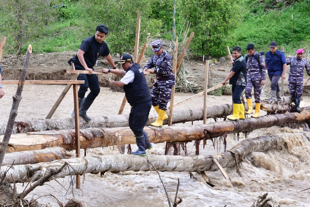
Acting Governor of South Sulawesi, Bahtiar Baharuddin, walked across a wooden bridge in the Latimojong District, Luwu, on Thursday (9/5/2024). Until now, some villages in Luwu are still isolated.
The floods and landslides that occurred continuously in South Sulawesi were not only caused by heavy rain. Forest destruction due to illegal logging and environmental damage in water catchment areas trigger hydrometeorological disasters that hit residents. It is urgent to implement appropriate policies in overcoming environmental problems in South Sulawesi before more victims fall.
Amidst chaos, Risno and his 26 relatives descended from the mountain, leaving Buntu Serek Village, Latimojong District, Luwu Regency, South Sulawesi, on Tuesday (7/5/2024). Walking for more than six hours, passing landslide mountains and crossing rivers, they arrived at the Flood Disaster Post in Belopa, the capital of Luwu.
This reckless action is not without reason. The condition of their settlements and homes on the slopes of Mount Latimojong is constantly threatened by landslides. Not only do old landslides worsen, but new ones also emerge.
"Despite the limited supply, there is still food available. Aid is also starting to come in. But what made us evacuate was the concern for the condition of our village and houses that no longer feel suitable. We are constantly haunted by landslides," he said.
Similar concerns were experienced by Hj Netti (53), a resident of Ulusalu Village, when contacted by phone on Monday afternoon, May 6, 2024. The continuous rainfall and cracks in the cliff walls around the village made her uneasy.

Aerial photos showing one area in Latimojong District, Luwu, South Sulawesi, on Monday (5/6/2024). Settlements in this area are surrounded by landslides.
Also read: Latimojong Surrounded by Landslides, Air Distribution Blocked by Bad Weather
"To be honest, we are all worried. There have been many new landslides. The old landslides are getting worse because the soil and rocks keep moving away. About 100 meters from my house, there are many cracks in the cliffs. We don't know where to go. We hope to be evacuated out," he said.
The natural disaster that occurred in nine districts in South Sulawesi since mid-April until early May has been a catastrophe for its residents. In less than a month, 36 people died due to landslides and flash floods.
As of Friday (10/5/2024), a number of villages in Luwu were still isolated due to broken roads and bridges and overflowing rivers. Not only is it cut off from Belopa, the capital of Luwu, but it is also cut off from the surrounding villages. The emergency bridge has not yet been completed. Helicopters belonging to the Indonesian Air Force, the Indonesian Army, the National Disaster Management Agency (BNPB), and the South Sulawesi Regional Police, went back and forth bringing aid and evacuating residents.
Indeed, in some areas the situation is gradually becoming more conducive. Some residents have started cleaning their houses from mud and various materials. However, the unpredictable weather still makes them uneasy.
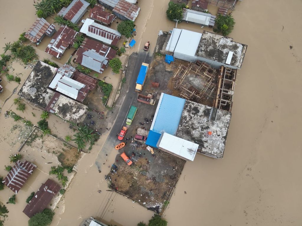
An aerial photo showing the flooded areas in Sidrap Regency, South Sulawesi, on Friday (3/5/2024). As many as six regencies were hit by floods and landslides.
Successive disasters
A series of disasters in South Sulawesi began when landslides occurred in Makale and Makale Selatan, Tana Toraja, on Saturday (14/4/2024). At least 20 residents died buried in the landslide. After Tana Toraja, floods hit Luwu Utara.
Also read: Floods and landslides hit a number of districts in South Sulawesi
The next incident was a landslide in North Toraja on Friday (April 26, 2014), which killed three residents. The next day, Saturday (May 27, 2024), flash floods and landslides struck Enrekang. Several road points collapsed and the houses of residents were filled with mud.
Not long after the aftermath of the disaster was addressed, Enrekang was hit by landslides again on Friday (3/5/2024). This disaster coincided with flash floods and landslides in Luwu, Sidrap, Wajo, Pinrang, and Sinjai. In Luwu, which was quite severe, 13 residents died buried in the landslide and swept away by flooding.
This disaster brings sorrow to the residents. In addition to casualties, hundreds of homes are damaged and buried or swept away by the current. Thousands of rice fields are damaged and submerged. Bridges and roads are cut off in many locations. In Wajo, floods affected 12,000 people. Meanwhile, in the Latimojong District, more than 6,000 residents are isolated.
One section of the road collapsed on the Enrekang-Toraja Axis in South Sulawesi on Sunday (28/4/2024). Flash floods and landslides that hit Enrekang on Saturday (27/4/2024) night left mud and a section of the road collapsed.
Forest logging
Head of the Center for Environmental Studies at Hasanuddin University, Ilham Alimuddin, said that this disaster is an accumulation of deforestation that has been happening for quite some time. This forest clearing is significant enough to reduce land cover. In addition, the disaster also causes damage in the river basin area.
Also read: Luwu Floods, Now and Past
"In the past, the Luwu, Enrekang, Toraja, and other regions still had a lot of forests. Now, they have been widely cleared for farming and settlements. There is also a gold mine in Luwu. All these factors are interconnected and contribute to the decrease in environmental resilience. Rain is only a trigger. Even if it is heavy, if there is still vegetation cover, it will not be as severe," he said.
These flood-prone areas are traversed by both large and small rivers. For example, in North Luwu there is the Rongkong River and the Masamba River. There is also the Sa’dan River which crosses Toraja, Enrekang, and Pinrang. In Luwu, there are several rivers, such as the Kaili River, the Suli River, and several other rivers.
In Sidrap and Wajo, which are bordering Lake Tempe, floods have become a routine occurrence when this tectonic lake overflows. The lake receives water from the flow of Bila River and Walanae River which also cross Sidrap and Wajo, as well as tens of small rivers. This lake is also the headwaters of Cenrana River before its flow ends at Teluk Bone.
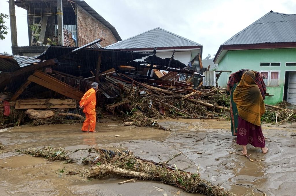
Condition of residents' houses in Siwa, Wajo, South Sulawesi, Sunday (5/5/2024), after being hit by flash floods on Friday (3/5/2024).
In highlands, the structure of rocky soils is formed from igneous rocks or granite and sediments. Over time, there is increasingly thick weathering that makes the soil unstable and eventually collapsing due to continuous rain.
Also read: Forests in South Sulawesi are Increasingly Critical
"I haven't calculated the exact data on the extent of this land opening. From satellite imagery, it seems clear that the opening is quite significant," he said.
The major flooding in Luwu is not a new occurrence. It has happened before in 2007 and 2014. In 2007, the death toll was 13 people.
According to data from the Ministry of Environment and Forestry, the forest area in South Sulawesi based on Minister of Environment and Forestry Decree No. SK.362/Menlhk/Setjen/Pla.0/5/2019 is 1,993,902 hectares.
This consists of protected forests covering 1,119,410 hectares, limited production forests covering 468,280 hectares, production forests covering 135,575 hectares, converted production forests covering 14,844 hectares, and natural/wildlife sanctuary forests covering 255,793 hectares.
A building in Masamba, North Luwu, South Sulawesi, is still buried under debris on Thursday (29/1/2021). Following last year's flash floods, many buildings have been abandoned and are still buried under debris.
If compared to the 2015 data from the Central Bureau of Statistics (BPS) of South Sulawesi, this number has significantly decreased. In 2015, the BPS of South Sulawesi recorded a total forest area in this region of 2,527,753 hectares. This area, among others, includes 1,213,864.99 hectares of protection forest and 128,459.84 hectares of production forest. The rest are conservation forests, tourist forests, and marine parks.
The major flood in Luwu is not a new occurrence. Floods have occurred in 2007 and 2014. In 2007, the death toll reached 13 people. However, there have been no efforts towards control or mitigation of the affected areas. Academics often provide feedback and recommendations regarding restructuring and control efforts.
"But indeed, not much has been done. Therefore, we really hope that in the future, the available inputs and recommendations will serve as a basis for the government to control environmental damage. Spatial planning also needs to be reassessed, determining which areas are vulnerable and which are no longer inhabitable," said Ilham.
He acknowledges that it is impossible to relocate all residents, especially with economic demands and increasingly limited residential land. Therefore, he hopes that education and mitigation efforts for residents will be improved, such as recognizing the conditions and natural symptoms in the surrounding area.
One of the rice fields with a backdrop of the Latimojong mountains which is traversed to get to Karangan Hamlet at the foot of Latimojong.
Also read: Customary Forests Encouraged to Minimize Environmental Problems in South Sulawesi
"How to educate residents to behave during disasters. For example, to survive or help themselves and others, not just hope for assistance. I also criticized the management of disaster management. There are many aids, but distribution is uneven and slow," he said.